Koh Samui mountain road — Jungle 360, Secret Buddha Garden, Khao Pom (2026)
This page is the Koh Samui mountain road as I ride it: 45.7 km from Chaweng, up to Jungle 360, across to the Secret Buddha Garden and Khao Pom, then on to the Maenam viewpoint. It is a chain of steep climbs, marked hard. The map lists the stops; below is how the road feels between them.
Grey — every road I have ridden; colour — this route. Tap a pin for Google Maps navigation. GPX works in Maps.me, Organic Maps, OsmAnd, Garmin.
Climbs and descents
Across — kilometres from the start, up — metres above sea level; the numbers at the bottom are the stops listed below. Bars under the chart and the yellow-and-black stretches on the map mark steep sections (over 12 %, dark red over 20 %). Elevation comes from SRTM satellite data, smoothed: an estimate, not a measurement on the road.
Stops along the way
-
Viewpoint
Jungle 360 Viewpoint
second-highest peak, full 360 view
Morning climb, before cloud sits on the peak.
-
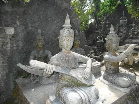
Photo: Roma Neus, CC BY 3.0, Wikimedia Commons TempleSecret Buddha Garden (Tar Nim)
Jungle sculpture park up on Pom Mountain — steep access road
Steep access; steady throttle, check the gate on site.
-
Viewpoint
Pom Mountain Viewpoint (Khao Pom)
Highest peak ~635m, central island — hard climb
Hard climb, about 635 m; the pin is approximate.
-
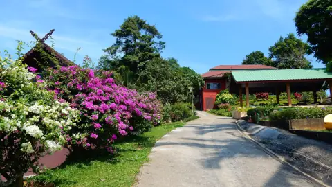
Photo: Roma Neus, CC BY 3.0, Wikimedia Commons AreaParadise Park Farm
Mountain animal farm, pool, sea view
Off the road this route follows; confirm they are open.
-
Viewpoint
Heaven Gate Samui
photo-zone hilltop, steep scooter road
Steep hilltop; the pin is approximate.
-
Viewpoint
Maenam Viewpoint (View Top)
north-coast hill, view to Koh Phangan
Last stop, Koh Phangan ahead, daylight left to descend.
The ride in numbers
I start in Chaweng. The 45.7 km is the mapped line between six stops. Most of it is a slow climb or a slower descent, so judge the day by the clock.
| Distance | 45.7 km from Chaweng, as mapped, including the steep legs up to the stops. |
|---|---|
| Riding time | About 2 hours if you take the steep parts slowly. With a pause at each stop, a full half day. Start early for daylight on the north coast. |
| Road | The climbs are steep, very steep in places. I would not promise a smooth surface the whole way, or lights after sunset. |
| Scooter | A 125cc automatic is what I take. I do not take a 50cc on these grades. Fill up in Chaweng, and check the brakes: the descents use them the whole way. |
| Direction | As drawn: Jungle 360, then Secret Buddha Garden and Khao Pom, then north to Heaven Gate and Maenam. Morning for the central climb; finish toward the north coast. |
Where to be careful
- Khao Pom, on the way down. The summit is about 635 m, and the brakes work all the way down. A hard grab on the front brake washes the tyre. I keep the speed down and brake before the bend, not in it.
- Heaven Gate. Heaven Gate is another steep scooter road, up to a hilltop. Look through the corner before you enter it, and let a faster bike past when you safely can.
- Rain. October to December is the wet season. I save the route for a dry morning — see rain and night.
- After dark. After dark, watch for dogs on the asphalt. Stay on your side and finish before dusk.
How to ride it
- Jungle 360 Viewpoint. From Chaweng I climb to the high ridge. The Koh Samui jungle route 360 starts here: first real grade, full 360 of coast and of the ridge ahead. See Jungle 360 for the view, then go.
- Secret Buddha Garden (Tar Nim). A jungle sculpture park on Pom Mountain. The steep access road is the work; the garden is the pause. Entry is about 80 baht — check the current price. Hours are roughly daytime and sources differ, so check on site. More on Secret Buddha Garden.
- Pom Mountain Viewpoint (Khao Pom). About 635 m, the centre of the island, and the hard climb. The pin is approximate, so follow the track. If the last metres are a footpath, walk. See Pom Mountain.
- Paradise Park Farm. A mountain animal farm in these hills, off the road this route follows. Whether they are open, check on site.
- Heaven Gate Samui. A hilltop on a steep scooter road. The pin is approximate. In cloud there is nothing to see, so take the descent slowly anyway.
- Maenam Viewpoint (View Top). A north-coast hill looking toward Koh Phangan. This is the last stop on the track. The road here is very steep, so keep daylight for the way down toward the north coast.
GPX and navigation
The GPX above is cut from my own log, so it follows the turns I rode rather than a straight line between pins. Import it into Maps.me, Organic Maps, OsmAnd or a Garmin; it works offline. Google Maps does not open a GPX. Tap a stop on this page and use Directions.
Pom Mountain Viewpoint and Heaven Gate have approximate pins. If the navigator and the road disagree, stay on the asphalt you can see and rejoin at the next stop. Download the file before you leave Chaweng.
I ride the file in the order on this page: Chaweng first, Maenam Viewpoint last. The other way around turns the very steep drop at the Maenam end into a climb, which I find harder.
Questions
Is the Koh Samui mountain road suitable for a beginner?
The climbs are the hard part, not the traffic. If you are still unsteady, ride the ring road first. This route needs a steady throttle uphill and brakes you trust on the way down.
How steep is the Secret Buddha Garden road?
Steep, and harder than the ring road. The climb toward Jungle 360 and the drop at the Maenam end are steeper still. Keep a steady throttle, and choose a place to stop before you need it.
Can a 50cc scooter climb Jungle 360 and Khao Pom?
I do not count on it. The grades are long and very steep, and a 50cc has little left when the slope kicks up again. I take a 125cc.
How long does the Koh Samui mountain route take?
About 2 hours of riding for 45.7 km if you take the steep parts slowly, or a full half day once you actually stop. Leave in the morning so the Maenam view is still in daylight.

Anton A.
I live on Koh Samui and have been riding the island for several years. Every road on these maps I rode myself — the track is a real GPS log. Spotted an error? Message me on Telegram: @abrameicev