Koh Samui viewpoints by scooter: the east coast loop (2026)
This is how I ride the Koh Samui viewpoints by scooter when I do not want the whole ring: an east coast viewpoints loop from Chaweng. I climb the ridge toward Lamai, drop to the 4169 for Lad Koh and Vikasa, then run north to the chedi above the airport. It is 38.3 km and marked medium, and the medium part is the climbs.
Grey — every road I have ridden; colour — this route. Tap a pin for Google Maps navigation. GPX works in Maps.me, Organic Maps, OsmAnd, Garmin.
Climbs and descents
Across — kilometres from the start, up — metres above sea level; the numbers at the bottom are the stops listed below. Bars under the chart and the yellow-and-black stretches on the map mark steep sections (over 12 %, dark red over 20 %). Elevation comes from SRTM satellite data, smoothed: an estimate, not a measurement on the road.
Stops along the way
-
Viewpoint
Beverly Hills Cafe Viewpoint
Chaweng-Lamai road, bay panorama
Unverified pin: follow the Chaweng–Lamai road and the cafe name.
-
Food & view
Jungle Club
Mountain cafe with a view above Chaweng Noi
Ridge cafe above Chaweng Noi; check on site whether it is open.
-
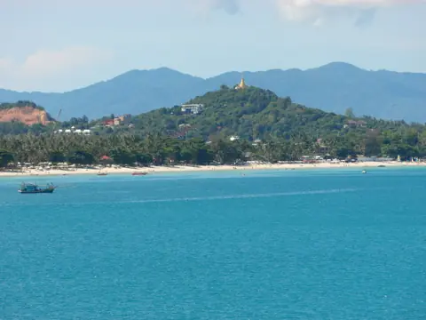
Photo: Roma Neus, CC BY 3.0, Wikimedia Commons ViewpointLad Koh Viewpoint
East-coast sea view right on ring road 4169
Short pull-off on the 4169; park fully off the lane.
-
Food & view
Vikasa Life Cafe (Lat Ko)
Clifftop cafe, panoramic ocean view
Clifftop cafe south of Lad Koh; check on site whether it is open.
-
Viewpoint
Overlap Stone
Balanced boulder viewpoint above Lamai
Steep pitch above Lamai; park off the lane and skip a wet rock.
-
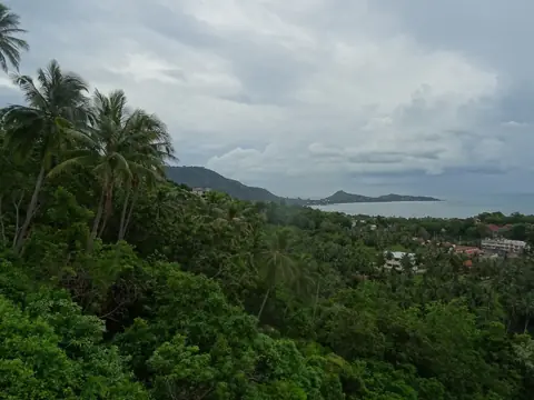
Photo: Christophe95, CC BY-SA 4.0, Wikimedia Commons ViewpointLamai Viewpoint
Hill deck over Lamai bay
Deck over Lamai bay, a short hop east of the boulder.
-
Temple
Wat Khao Hua Jook
Hilltop chedi with airport views — easy climb
Easy climb, airport in view; dress modestly.
The ride in numbers
| Distance | 38.3 km from Chaweng, mapped as the east coast viewpoints loop: ridge south of town, a stretch of the 4169, then back north to the airport hill. |
|---|---|
| Riding time | About 1 hour 15 minutes non-stop at 30–40 km/h. With the seven stops it is a half day. A long pause at both cafes takes the afternoon as well. |
| Road | The roads up to the ridge cafes are very steep, and Overlap Stone is steep. Lad Koh is the ring road, and that stretch climbs too. |
| Scooter | A 110–125cc automatic is the bike I use on these climbs. I do not count on a 50cc for these climbs. Read 50cc or 125cc before you pick. Leave Chaweng with a full tank. |
| Direction | South from Chaweng first, north to Wat Khao Hua Jook last. Climbs in the morning, chedi at the end. |
Where to be careful
- Rain on the hills. In my experience the first minutes of a shower slick the asphalt. In Oct–Dec it hangs on. If the road shines, wait. See rain and night riding.
- After dark. I finish the loop in daylight.
- Back on the 4169. At Lad Koh you are back in ring-road traffic. The road from Chaweng Noi toward Lamai still climbs, so keep your lane.
- Leaving the scooter. Pull fully off the lane. If there is no gap, ride on to the next stop.
How to ride it
- Beverly Hills Cafe Viewpoint. Climb the Chaweng–Lamai road for the bay panorama. The coordinate is unverified, so follow the road and the name, not the pin on its own.
- Jungle Club. Same ridge, a bit further, above Chaweng Noi: the mountain cafe. Check on site whether it is open.
- Lad Koh Viewpoint. Drop east onto the 4169. The sea view is beside the ring road, a short pull-off. The same place is a stop on the ring road.
- Vikasa Life Cafe (Lat Ko). Continue south to the clifftop cafe and a wider ocean view. Check on site whether it is open.
- Overlap Stone. Turn inland above Lamai to the balanced boulder. The pitch here is steep. Park off the lane, and leave the boulder alone if it is wet.
- Lamai Viewpoint. A short hop east to the deck over Lamai bay. I choose here whether the chedi is still worth the ride north.
- Wat Khao Hua Jook. North to the hilltop chedi, the airport in view, and the easy climb of the day. Dress modestly, and follow whatever is posted at the entrance.
If the ridge is already hot when you leave Jungle Club, skip one cafe. Keep Overlap Stone and the wat.
GPX and navigation
The GPX above is cut from my own log. It reaches Lad Koh, Vikasa and the boulder; Beverly Hills and Jungle Club sit off it, so follow the road and the cafe names. Load it into an offline map app or a Garmin on wifi.
Google Maps does not open a GPX file. Take Directions for one stop at a time from the map on this page. A single route from Chaweng to the wat will stay on the 4169 and skip the ridge.
Beverly Hills Cafe Viewpoint is the unverified coordinate. If the pin sits off the pavement, ride the track and look for the name. Jungle Club is off it too: use the name, not only the pin.
The file follows this stop order: south from Chaweng, and after Lamai Viewpoint it turns north to the chedi instead of riding on around the island. Backwards works, but the steep pitches come as descents.
Questions
How long is the Koh Samui viewpoints by scooter ride?
About 1 hour 15 minutes of riding for the 38.3 km. With all seven stops, plan a half day and be off the ridge before dark.
Is the east coast viewpoints loop OK for a beginner?
It is medium for the steep climbs, not the length. If you hold 30–40 km/h and brake before corners, start in the morning.
What time of day should I ride the viewpoints on Koh Samui?
Morning. The climbs are cooler, and you still have daylight for the steep road back. Start early enough to be off the hills before dark.
Do I need a motorcycle license to scooter this route?
Yes. Carry your national licence together with a 1949 International Driving Permit that shows category A — the permit is only a supplement, not a licence by itself — and wear a helmet. A car-only licence does not cover a scooter.

Anton A.
I live on Koh Samui and have been riding the island for several years. Every road on these maps I rode myself — the track is a real GPS log. Spotted an error? Message me on Telegram: @abrameicev