Khao Pom (Pom Mountain) — riding to the highest point of Koh Samui (2026)
Khao Pom is the highest peak on Samui, about 635 m, right in the middle of the island. It is not a roadside viewpoint you pull into for five minutes: the last part is a hard climb, and this page is about whether your scooter and your riding are ready for it, and how to do it without drama.
Grey — every road I have ridden; colour — this route. Tap a pin for Google Maps navigation. GPX works in Maps.me, Organic Maps, OsmAnd, Garmin.
Places on the map
-
Viewpoint
Pom Mountain Viewpoint (Khao Pom)
Highest peak ~635m, central island — hard climb
The map pin is approximate, so check the last turn locally, park on level ground on the centre stand, and go in the morning before the clouds build.
-
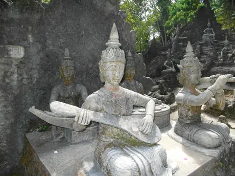
Photo: Roma Neus, CC BY 3.0, Wikimedia Commons TempleSecret Buddha Garden (Tar Nim)
Jungle sculpture park up on Pom Mountain — steep access road
Ride here on the way to Khao Pom; the road to the peak is very steep, so take it at low speed and descend with short brake pulls.
-
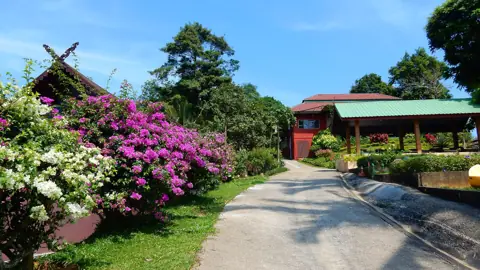
Photo: Roma Neus, CC BY 3.0, Wikimedia Commons AreaParadise Park Farm
Mountain animal farm, pool, sea view
-
Viewpoint
Jungle 360 Viewpoint
second-highest peak, full 360 view
Getting there by scooter
Khao Pom sits in the centre of the island, so from any coast you leave the 4169 ring road and climb inland. From Chaweng I ride south on the ring road towards Lamai and turn up into the hills; if you are staying in Lamai, the coast is closer and the climbing starts sooner. The simplest way to aim is the Secret Buddha Garden, which is up on the same mountain. In my experience the steep road up there is where the ride gets serious.
The last climb is very steep. The map pin for the peak is approximate, since I have not confirmed it on the ground. Check the last turn locally and do not trust the map to the metre.
I cannot vouch for a proper car park at the top. Leave the bike on its centre stand on level ground, never on the slope.
What you get up there and how long to stay
The point of Khao Pom is simple: it is the highest point of Koh Samui, and you ride most of the way up it yourself. How open the view is depends on exactly where you stop, on trees and on haze. On a clear morning you look down over the green middle of the island towards the sea. On a hazy afternoon you may mostly see jungle and cloud. I would not promise a full panorama. If an unobstructed 360° view is what you are after, Jungle 360 is the safer bet.
Plan for 20–40 minutes at the top. Riding up and down plus a stop at the Secret Buddha Garden makes a comfortable half day from Chaweng or Lamai.
- Water: bring your own. I would not count on a shop near the peak, so check on the way up.
- Fuel: fill up on the ring road before you turn inland. Climbing burns more than you expect.
- Shoes: closed shoes help if you have to put a foot down on a steep bend.
When to go
Go in the morning, ideally leaving the coast by 8–9. The air is clearer, the heat is lower, and in my experience clouds tend to build over the centre of the island after midday, which can hide the view and bring a shower. A cooler engine and cooler brakes on a long descent are a bonus too.
Do not plan this one for sunset. Coming down a very steep mountain road in the dark is the worst way to end it.
In the dry months the main enemy is heat. Take a break halfway up, for you and for the bike.
Combine it with
Khao Pom is part of my mountain roads route (45.7 km), which links Pom Mountain and the Secret Buddha Garden into one ride. It is the easiest way to do the climb without guessing turns.
- Secret Buddha Garden (Tar Nim): a jungle sculpture park on the same mountain. It is on the same mountain, and the road on to the peak is steeper.
- Paradise Park Farm: a mountain animal farm on the same slopes, open 10:00–19:00, entry about 400 baht. It is a good pause if you are riding with kids.
- Jungle 360: to the north-east. It is a separate hard climb, and I would not do both on one morning unless you are confident on steep roads.
If you are still choosing a bike for this, read 50cc or 125cc first. For Khao Pom the answer is 125cc.
Questions
What is the highest point on Koh Samui?
Khao Pom (Pom Mountain), about 635 m, in the centre of the island. Jungle 360 is another high viewpoint to the north-east.
Can I ride up Pom Mountain on a 110cc scooter?
Solo, possibly, but it will be slow on the steepest pitches. A 125cc is the sensible minimum, and I would not take a passenger up on anything smaller.
Is the Khao Pom road OK for a beginner?
I would not make it your first ride. Get a few days on the ring road first, until braking before bends and riding slowly downhill feel normal.
How long does the trip take?
Allow half a day from Chaweng or Lamai, including the Secret Buddha Garden and 20–40 minutes at the top.
Can I go up during the rainy season?
On a dry morning, yes. After heavy rain the very steep grade is slippery, so wait a day.

Anton A.
I live on Koh Samui and have been riding the island for several years. Every road on these maps I rode myself — the track is a real GPS log. Spotted an error? Message me on Telegram: @abrameicev