South-west Samui by scooter — Taling Ngam, Lipa Noi and the west coast sunset (2026)
This is the afternoon ride I recommend to people who have already seen Chaweng and Lamai. You go south to the island's quiet corner, then turn up the west coast to Taling Ngam and Lipa Noi, timing it so you reach the sea as the sun goes down.
Grey — every road I have ridden; colour — this route. Tap a pin for Google Maps navigation. GPX works in Maps.me, Organic Maps, OsmAnd, Garmin.
Climbs and descents
Across — kilometres from the start, up — metres above sea level; the numbers at the bottom are the stops listed below. Bars under the chart and the yellow-and-black stretches on the map mark steep sections (over 12 %, dark red over 20 %). Elevation comes from SRTM satellite data, smoothed: an estimate, not a measurement on the road.
Stops along the way
-
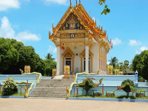
Photo: Roma Neus, CC BY 3.0, Wikimedia Commons TempleWat Khunaram
Mummified monk Luang Pho Daeng
-
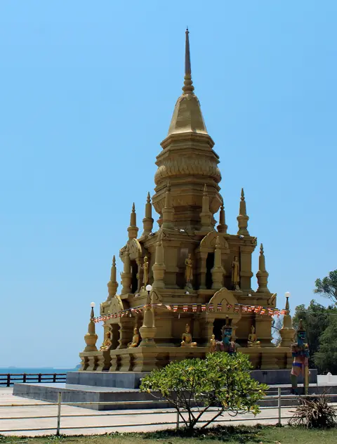
Photo: Per Meistrup, CC BY-SA 4.0, Wikimedia Commons TempleLaem Sor Pagoda
Golden chedi by the sea, SW tip
-
Beach
Thong Tanote Beach
Remote palm-fringed southwest corner
The map pin is not verified yet, so if the GPX and the pin disagree, ask locally at the last turn-off.
-
Beach
Taling Ngam Beach
Tranquil southwest beach, Five Islands sunsets
-
Food & view
Air Bar (InterContinental Taling Ngam)
Clifftop sunset bar, west coast
It is inside the hotel, so check at the entrance whether non-guests can go up and from what time.
-
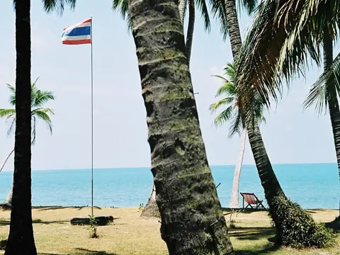
Photo: Tsui, CC BY-SA 3.0, Wikimedia Commons BeachLipa Noi Beach
Best sunset beach, west coast
Arrive about half an hour before sunset, and switch your lights on before you pull back onto the 4169.
-
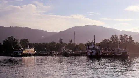
Photo: Per Meistrup, CC BY-SA 4.0, Wikimedia Commons AreaLipa Noi Pier (Raja Ferry)
Car ferry, west coast
The ride in numbers
| Distance | 36.3 km one way as mapped in the GPX. The coastal stops require separate detours; this distance does not include riding right up to them or to Lipa Noi pier. |
|---|---|
| Riding time | About an hour of riding at a relaxed 40 km/h, one way. With the temple, a swim and the sunset, it takes an afternoon. I leave Chaweng around 1–2 pm. |
| Road | The mapped route has no steep sections. Coastal detours vary: the approaches towards Taling Ngam and Air Bar include very steep sections, and the approach towards Lipa Noi Beach is steep. |
| Scooter | Any 110–125cc automatic. Level: easy. Check your fuel before leaving Chaweng. |
| Direction | South first, then north up the west coast. The sea stays on your left and the sunset comes at the end of the ride, not the start. |
Where to be careful
- Side roads to the coast. Take the turn-offs to Laem Sor and Thong Tanote slowly. Go down slowly, use both brakes gently and look out for sand on the concrete near the sea.
- Low sun. From late afternoon the west coast stretch points you into the glare. Sunglasses or a tinted visor help, and so does giving cars more room than usual.
- The ride back after sunset. Watch for animals on the road after dark. Check your headlight before you leave Chaweng. Read riding in rain and at night if you have not ridden here in the dark.
- Rain season, October to December. Afternoon downpours are common. Wait under a roof until visibility improves, because the first rain makes the road slick.
How to ride it, stop by stop
- Wat Khunaram. This is the first stop on the 4169 heading south, the temple with the mummified monk. Cover shoulders and knees. More on the Wat Khunaram page.
- Laem Sor Pagoda. Laem Sor is on the south coast, near Thong Tanote. Allow for a separate detour to the pagoda.
- Thong Tanote Beach. A remote palm-lined corner close to Laem Sor. I have not verified the map pin, so check the turn on site or ask locally. See Thong Tanote.
- Taling Ngam Beach. From here you are on the west coast. Swim only when the sea is calm.
- Air Bar (InterContinental Taling Ngam). A sunset bar on the cliff, inside the hotel.
- Lipa Noi Beach. The main sunset stop. The beach faces west and is quiet in the evening.
- Lipa Noi Pier (Raja Ferry). The car ferry pier. Around ferry times, expect trucks and cars pulling onto the road.
GPX, navigation and getting back
The GPX comes from my own GPS log. It works offline in Organic Maps, OsmAnd, Maps.me or a Garmin. Google Maps does not open GPX files, so if you use Google, tap a stop on the map and use Directions.
After Lipa Noi you have two ways back. You can return the way you came, which means a road you already know, now in the dark. Or you can keep north on the 4169 and close the loop around the island; the ring road page covers that half. Either way, most of the return will be after dark, so ride slower than you did in daylight.
Questions
Is the south-west route OK for a beginner?
Yes, it is rated easy. The mapped route has no steep sections, but some coastal detours are steep or very steep. Take the short side roads to the coast slowly, and avoid the return in the dark if you have never ridden at night.
What time should I leave Chaweng to catch the sunset at Lipa Noi?
Around 1–2 pm if you want to stop at every point, or 3 pm if you skip most of them. The sun sets roughly between 6 and 6:45 pm depending on the month, so check the time for your day.
Can I see Taling Ngam and Lipa Noi on a ring road day?
Yes. Both are just off the 4169. From Chaweng, ride south through Lamai first, then continue up the west coast, allowing time for your stops before sunset.
Do I need a license to ride here?
Wear a helmet. Tourists need a national motorcycle licence together with a 1949 IDP showing A for stays of up to about three months; longer stays require a Thai licence. Fines: up to 2,000 baht for no helmet and up to 1,000 for not carrying a licence.

Anton A.
I live on Koh Samui and have been riding the island for several years. Every road on these maps I rode myself — the track is a real GPS log. Spotted an error? Message me on Telegram: @abrameicev